Geology and Rock Geochemistry
The geology at Oswego as represented by the Oswego-Geddes Bertrand area includes Cambrian to Ordovician stratigraphy from the Eldorado Dolomite through the Eureka Quartzite Formations. As at the Lookout Mountain and the Windfall Trends, there is a strong north-south structural control along with northeast- and northwest-directed cross structures. These geologic trends are evident in geologic mapping, regional magnetic, and soil and rock geochemistry.
Distribution of Gold and Silver in Rock Samples at Oswego Target Area
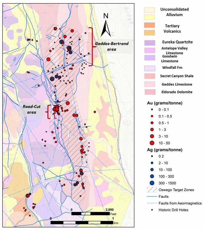
Timberline’s focus to-date at Oswego has been on rock sampling and data compilation. Assays for 54 rock samples at Oswego are summarized below. Most notably, 9 grab samples collected at approximately 20 feet spacing over a 180-foot section of road cut along a moderately east-dipping, strongly mineralized fault zone (the Road-Cut target) averaged 13.623 grams/tonne (g/t) gold. The results are consistent with historic reports of 12.38 g/t gold (0.361 ounces/ton (oz/ton)) over a 281-foot channel sample in this area. At the Geddes-Bertrand target, 4 samples graded greater than 100 g/t silver, up to a maximum of 1,625 g/t (47.4 oz/ton) silver.
Assay results from Oswego Trend Rock Sampling
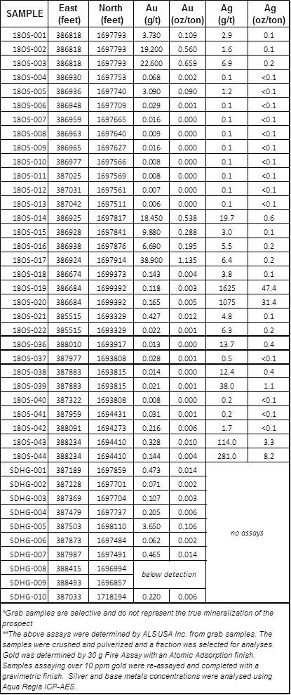
The highest grade assays typically coincide with the intersection of north-, northwesterly-, or northeasterly-trending faults. Widespread bleaching and/or “sanding” (leaching of carbonate matrix) is noted as well, which is commonly associated with gold-silver mineralization within the carbonate rocks.
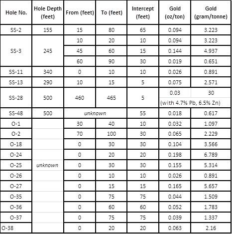
Historic Drilling
Available historic records from the 1980’s and early 1990’s, and field review, indicate that approximately 70 shallow drill holes targeted gold along fault structures in the Oswego trend. Results varied widely, but included multiple intercepts which are overall consistent with the recent grab sample assays, including:
Historic Drill Hole Gold Assay Results from the Oswego Road-Cut Target Area
Cautionary Statement
Historic drill data has been compiled and reviewed including drill logs, laboratory assay certificates, and location maps. Drill sites have been identified and confirmed through field review. A Qualified Person has not done sufficient work to classify the historical information as a current mineral resource, and the Company is not treating the historical information as a current mineral resource. Additional drilling and analysis will be required to verify the historical information or create a current mineral resource.
Exploration Planning
Exploration along the Oswego trend and the Oswego Road-Cut target will be integrated with and will capitalize on Timberline’s discovery experience at nearby Lookout Mountain.
The occurrence of wide-spread gold and silver mineralization in outcrop in the Oswego to Geddes-Bertrand area, as highlighted by the very high-grades at the Road-Cut target, suggests the existence of a robust gold system. Several rock formations on the trend are well-known as favorable hosts for large Carlin-type deposits in the region. The Company will continue exploration of the area with a focus on potential links to the large foot-print of mineralization and structural-controls in the nearby Lookout Mountain area. We anticipate completing additional CSAMT and gravity studies in preparation for drilling.